Asia, a land of wonders - these are my thoughts, experiences and travel tips from SE Asia

Monday, December 19, 2011

Thailand Golden mount Wat Saket temple

Wat Saket Ratcha Wora Maha Wihan
วัดสระเกศราชวรมหาวิหาร (short name is Wat Saket) is a Buddhist temple or Wat in Pom Prap Sattru Phai district, Bangkok, Thailand.

The temple is not far from Sanam Luang and the Wat PraKaew, it is a walking distance.

Also not far from this temple the famous street lays: Soi KhaoSan.

The temple dates back to Ayutthaya era, when it was called Wat Sakae.


King Rama I renovated the temple and renamed it to Wat Saket. Phu Khao Thong (Golden mountain, ภูเขาทอง) is a steep hill inside the Wat Saket compound. It is not a natural outcrop, but an artificial hill. During the reign of King Rama III (1787–1851) the decision was made to build a Chedi of huge dimensions to add to the Wat Saket temple.

However, the large Chedi collapsed during the construction process because the soft soil beneath would not support it. The resulting mud-and-brick hillock was left alone for about half a century, taking the shape of a natural hill and becoming overgrown with weeds. Since then it looked like a natural small mountain it received its name of "Phu Khao" (ภูเขา) at that time. Finally under King Rama IV, a small Chedi was built on the hilltop. This smaller structure was finished under King Rama V (1853–1910), when a Buddha relic from India was housed in the Chedi.


In the 1940s the surrounding concrete walls were built to prevent the hill from eroding. The Wat Saket was built in the early 20th century of Carrara marble. There is an important festival at Wat Saket every November that includes a beautiful candlelight procession up Phu Khao Thong.

This festival is Loy Krathong which is celebrated all around Thailand but this temple has a nice festivity going on at that time.


 Phu Khao Thong has become a popular tourist attraction in Bangkok, but the rest of the Wat Saket temple area is much less visited.

 Good to know: 
* Go before 5:00 PM as the temple closes for visitors.
* Entrance fee is 10 BHT (as of 2011) but giving a bit more would be good.
* Good place for taking photos of the city.

Need more details - drop us a note using the contact page.

Wednesday, November 16, 2011

Water begins to drain out of Bangkok

After more than a month of flooding in Thailand and in Bangkok, the flooding water level starts to go down like showing us a sign of peace. So far there were more than 500 casualties of the flooding throughout Thailand. Below there is a flooding map showing the current situation as of 15-16 Nov 2011.

Bangkok flooding update map as of 15-16 Nov 2011
While in many areas of Bangkok the water is almost drained out, the battle still takes place in the North part of the city where the water inflow is just to high for the current pumps. It is true that government allocated a lot of water pumps to drain out the water from the capital. Below here there is the updated flooding situation in a visual presentation.
Water inflow in the North part of Bangkok


* The images are provided by various internet sources and we are not responsible for the accuracy of the data. This is just a blog that wants to keep its readers up to date with the flooding situation in Bangkok and provide other more or less subjective information - just like any other blog.

Sunday, November 13, 2011

Bangkok flooding in pictures

Bangkok flooding in pictures route Suttthisan - Lad Phrao - Central Lad Phrao - Chatuchak Park - Saphan Kwai

In the last weeks I heard and read a lot of news, sometimes I was looking at TV in the evening and the news were announcing that the place I live is flooded "water reached to intersection of ..." and the thing is that there was no flooding and still there is none.

Boat out in flooded Bangkok
What I did was to decide that I have to check by myself where there is and where there is no water and flooded areas. Said and done, took out the camera and started the journey. First things was to travel up on Rachada road until I reach water: Fortune city is dry, so is Thailand Cultural Center area, Robinson and BigC and further on Hway Kwang. Going further I reach to Sutthisan intersection - still no flooding water around here and I went further up. About 400-500 meters away from Sutthisan-Rachada intersection there is the Khlong Bang Sue and North of this canal is where the flooding starts.

Pictures in this article illustrates the journey from Chaophraya Park hotel on Ratchada road towards the North, reaching Lad Phrao intersection and then turn left on LadPhrao road.
Truck taxi carrying people - most of them are free of charge
Foreigners playing in the water on Rachada road
Truck ride in the flooded areas of Bangkok
Shell petrol station flooded and closed - Rachada road
Lad Phrao intersection on Rachadapisek road
Perfect blue sky in Bangkok - not much pollution during floodings
Lad Phrao road flooded
All here is flooded. The water is just enough deep for not allowing the small cars to pass but not high enough to produce any damage to houses or big cars - this looks like a scenario written already. Water is just there, not to much, not to less - just perfect to create an inconvenience and from my point of view, to spend more money on booths and water protection.

So from Lad Phrao road towards Central Lad Phrao and Union Mall everything is under water. Further on the truck went left towards Chathuchak Park which got some water as well. Mostly is the roads that resemble to a sea of water. The sky is a perfect blue in Bangkok which, believe me, is not easy to find - I do assume this is a result of less and less pollution. Probably only 10-15% of the cars are running in Bangkok these days.

Heading towards Saphan Kwai
Waiting for the bus in Bangkok
Pahon Yohin road near Chatuchak Park - flooded
Sea of Bangkok - water as far as you can see
Pickup truck playing in the floods
All the parkings are full with cars and so are the bridges and express-ways where the people parked their cars for escaping the flood to come.

They say Bangkok has been voted as the No.1 place for travel - I guess it was before the flooding :)

Royal Thai Army trucks for passengers in flooded areas it free of charge
Chatuchak weekend market intersection
Just before reaching BigC at Saphan Kway the flooding stopped and everything is dry again - now we are back South of Khlong Bang Sue.

Conclusion: Inner Bangkok is flooded in a lot of places but it is just a matter of inconvenience for the citizen as the water did not reach dangerous levels and it starts to recede as well. By middle of December should be all gone, this would be my forecast on the Thai flooding of 2011.

Drop me a line if you are flooded or you want to post your pics or comments or ideas, I may help you with this.

Saturday, November 12, 2011

iGoogle gadgets resource and intro


iGoogle gadgets resources and introduction for Gadgets website 
http://gadgets.vidagate.com


We would like to introduce a new website dedicated to iGoogle gadgets and website gadgets of all kind. There are cute gadgets, utilities, pictures of cars, landscapes, women, cute girls and more. We have iGoogle photos and game gadgets ready to use in your IG page or embedded into your website.


Here are a few iGoogle gadgets and you can fine more at http://gadgets.vidagate.com


Word and Character calculator
http://gadgets.vidagate.com/gadget/tools/word-and-character-calculator/


Sex positions advise - one position per day
http://gadgets.vidagate.com/gadget/picture-images/sex-positions-advice-gadget/


Sudoku game for iGoogle
http://gadgets.vidagate.com/gadget/fun-and-games/sudoku-game-gadget/


Daily Asian cute models
http://gadgets.vidagate.com/gadget/picture-images/daily-asian-models/


Find nice iGoogle gadgets here : http://gadgets.vidagate.com


Website gadgets are small web applications that run on one or more sites, including iGoogle, orkut, other OpenSocial containers, Google Desktop, and other sites all over the web that are able to use the gadgets. Gadgets are usually written in a module language using XML that contains HTML and JavaScript.

Friday, November 11, 2011

Loy Krathong 2011 among the floods in Bangkok

Loy Krathong 2011 among the floods in Bangkok

Loi Krathong or Loy Krathong ( ลอยกระทง ) is a festival celebrated annually throughout Thailand and other countries around.

Loy Krathong takes place on the evening of the full moon of the 12th month in the traditional Thai lunar calendar. In the western calendar this usually falls in the month of November.
Loy literally means "to float" while krathong refers to the lotus-shaped receptacle which can float on the water.

Originally, the krathong was made of banana leaves or the layers of the trunk of a banana tree or a spider lily plant. A krathong contains food, betel nuts, flowers, joss sticks, candle and coins. Modern krathongs are more often made of bread or styrofoam. A bread krathong will disintegrate in a few a days and be eaten by fish and other animals. The traditional banana stalk krathongs are also biodegradable.

On the 10th of November 2011 we have chosen to attend to Loy Krathong in one of the 16 or 18 parks opened in Bangkok for this celebration, more exactly in the Lumpini Park which is on the Witthayu Rd. This is a nice park right in the middle of the business district of Bangkok and it has entrance from Silom, Sathorn, Witthayu and Rachadamri roads.

Loy Krathong floating- Bangkok parks
There were not to many people due to the floodings in Thailand so the ones that had the time went to the park and float the krathong which also has a candle and a few incense sticks as a part of the design. People also put a few coins on the krathong and then make it float on the water just after lighting the candle and the incense sticks. It is pretty nice, an occasion that makes people do activities and be together in the same place.


The next dates for Loy Krathong celebrations in Thailand and Bangkok are:

Year  - Date Full moon of the 12th Thai month
2010 - 21 November
2011 - 10 November
2012 - 28 November

There are many activities normally organized during this festival in Thailand, for example river cruises, fireworks in various places of Bangkok, there are many festivities around the temples (called ngan wat) and these are really nice.

You can drop us a line (using the contact page) if you want to know more about Loy Krathong festivities or plan a trip to Thailand!

Monday, November 7, 2011

Hong Kong - Happy Valley holiday

A short break in Happy Valley, on the island of Hong Kong

* After quite a pleasant flight, the plane landed on the Hong Kong International Airport which is a bit far from the city, near Lantau island. The immigration procedures didn't took that long like in other places around SE Asia so I would say its fine in HK.

Next step was to reach into the city of Hong Kong so I got my train ticket - yes, the Airport Express is a superb train that takes you in about 25 minutes from airport straight in the city of Hong Kong - at Central station. Price is 180 HK$ for round-trip which is way cheaper than the taxi - which I heard could be around 300 HK$ (one way).

From Central station I was heading towards Happy Valley where I had my hotel booked and the best way for doing this, along with my heavy bags, was to take a taxi - short ride, about 50HK$ and in 10 minutes I was in front of the hotel.
Emperor Happy Valley hotel - Hong Kong

 My accommodation in Hong Kong was Emperor Hotel Happy Valley, a hotel that was recommended by a friend in Hong Kong and turn out to be a good place to stay. I was staying on the 21st floor with a nice view. Hotel is surrounded by narrow streets and very high buildings in a truly Hong Kong style landscape. Good thing about staying here is that from Happy Valley is easy to access other interesting areas of Hong Kong like Causeway Bay, Wan Chai, and further on as there is train connection to all the city.


Happy Valley is a mostly residential suburb of Hong Kong, located in the northern part of Hong Kong Island.

Happy Valley is made up of upper income residential areas, and its residents include of a mix of Hong Kong natives and foreigners as well. Two of the tallest residential buildings in Hong Kong, the "Highcliff" and "The Summit" are located in Happy Valley facing Mount Nicholson and the rest of Hong Kong.

Feeling surrounded in Happy Valley

Tall buildings in Hong Kong - Happy Valley
Happy Valley also provides a number of high end restaurants and hotels, and is a rendezvous point for many Hong Kong celebrities. Because of this, much paparazzi activities are present in the area. Many Hong Kong television series are filmed in Happy Valley, too.

The Happy Valley Racecourse is still operational today - beware of the traffic during races, as it would be traffic jam and difficult to find a parking spot for your car.


Tofu meal in Hong Kong - delicious

Dumplings with beef / chicken - absolutely great food in Hong Kong

A glass of beer in Hong Kong - San Miguel is popular

Tofu and lamb fried with onion and white rice - Hong Kong food

Hong Kong Happy Vally landscape - street and restaurants
Some of the best food in Asia I have eaten in Hong Kong. Delicious Chinese foods is available on cheaper street restaurants or more expensive ones. Sure, it is recommended to have a guide that speaks Cantonese and knows what to order as a lot of food menus would be written only in Chinese although some of them have English language and some of them have pictures as well.

Almost forgot, in Happy Valley you can enjoy night life in a few bars or just go to Wan Chai and discover further on, there are a few quite nice restaurants and beer bars as well as go-go style bars with girls from all over Asia willing to have a drink with you. It is not exactly like in Bangkok tho, Hong Kong is more quiet and hidden behind closed doors while in some Bangkok places inside or outside the bar is almost same!

Cheers! Enjoy and let me know if you have any comment/questions.

Sunday, November 6, 2011

Bangkok Rachadapisek road flooded

Rachadapisek is quite an important road in Bangkok, it is also quite long stretching from South of city all the way up to North. Some of the MRT line is following Rachada road as well.

Below are some flooding pictures as of 06 November 2011. These pictures are taken in front of Chaophraya Park hotel on Rachada road which is 500 meters North of Sutthisan intersection. Starting this place and further up towards Lad Phrao both sides of the Rachadapisek road are flooded and water is increasing with every minute.

We could see water rising about 5 cm is approx. 10 minutes which is quite much.
Klong Bang Sue on Ratchada road - high water level flooding houses along

Here the Rachada flooding starts

Bus on Rachada road - small cars are not allowed further than Suthisan


Royal Thai Army transporting passengers to the other side of LadPhrao intersection

Sea of Bangkok directly on Rachada road
Bangkokians gathering to see the flood (most of them)


Khlong Bang Sue - on Rachada road, high water level 06 Nov 2011

Water rising out from the underground channels on Rachadapisek road

The road from Suthisan intersection further on Rachada road is closed for small cars.

Ratchadaphisek (Thai: รัชดาภิเษก) is the district that follows the northeastern portion of Ratchadaphisek Road. It is located north of Sukhumvit, east of Phahonyothin and west of Ramkhamhaeng districts. Since the completion of the metro (MRT) line, Ratchadaphisek has developed into an entertainment mecca for the locals with dozens of clubs, theatres, karaoke bars, bowling alleys and even an ice skating rink and more. Foreign visitors are drawn to its seafood restaurants, cultural performances and "massage parlours" (brothels). The part of Ratchadaphisek Road that runs along the Queen Sirikit National Convention Centre is dealt with under Sukhumvit.


The northern runoff is now flowing towards Bangkok's Saphan Khwai intersection, in an inner district of Bang Sue, about 500 metres away, reports said.

The mass volume go water on Monday morning inundated the Kampaengphet intersection near Chatuchak Sunday market. The floodwater was 30 to 40 centimetres deep, impassable for small vehicles.

Traffic police at Bang Sue police station expected the floodwater to arrive at Saphan Khwai intersection about noon today, according to the reports.

On Vibhavadi Rangsit road, the runoff from Lat Phrao intersection arrived at headquarter of the country’s largest local daily, Thai Rath, flooding all lanes of the main road.

The floodwater was reported at 50 centimetre and impassable for small cars.


Water enters Bangkok: my-asia-travels.blogspot.com/2011/11/flood-water-enters-bangkok-city.html

Flood water enters Bangkok city

Updated situation, as of 8 Nov 2011, on the Bangkok flooding is here  - one thing is for sure: the water enters Bangkok city from below, from down under, from the canals under the city and then it pops-up in houses, yards, streets.

Click on the flooding map on the left to see the full size image.

In the last couple of day the water was allowed in, into city of Bangkok flooding arease of Lak-si and coming down to Ratch-Yothin (Major Ratcha-Yothin) intersection and down to Lad Prao. Water is also present at Rachada-LadPrao intersection, yesterday announcing that water reached Chaophraya Prak Hotel which is very close to Sutthisan intersection (Rachadapisek road).

What is coming next we shall see. I think this is a proof that other areas of the city can be flooded and nothing can actually be safe here. So this also means that condo and houses/land prices will not grow exponentially in the non-flooded areas compared to flooded areas - but this is a speculation only - mine. :)

Anyway it seems that Chatuchak Market is open even tho the flooding water is at its gates. They are using pumps to get rid of the water allowing people to do shopping. About 50% of the shops are actually open.

On Phahon Yothin road water from the north is spreading to the Kamphaeng Phet intersection and creeping nearer to the Mor Chit northern bus station, reports said on Sunday. At the Lat Phrao intersection, the water has reached in front of St John's University.

In the west, the floodwater has reached Soi Kamnan Maen in Bang Ban district and previous reports say that water will reach Rama II road shortly (this was on TV on Saturday night)

The risk is higher now than last week when the water tides were the highest. Why is that? Why this turns out to be a never-ending story? I don't know but I know "we" like publicity!

There is a updated flooding and risk map below for Eastern Bangkok:
Eastern Bangkok flooding protection and risk

However, a lack of coordination between water management officials at both the city and national level has probably put more areas in danger.

In a "new" worst-case scenario, the only option to solve the crisis would be to let the water drain through flood-ways which are not regulated by gates or pumps resulting in no control over the flow.

"Water drainage via flood-ways is something people on the job don't want to talk about," said Sutat Weesakul, a member of the Water Drainage in Disaster Areas Committee.

"They all know that by draining water via flood-ways, people downstream could be at high risk of being flooded."

The eastern side of Bangkok, home to Suvarnabhumi airport and the Bang Chan and Lad Krabang industrial estates, is a major concern for business, politicians and officials.

Rachadapisek road flooded - my-asia-travels.blogspot.com/2011/11/bangkok-rachadapisek-road-flooded.html


Friday, October 28, 2011

Bangkok flooding protection measures

As of 2nd of November 2011 instead of saying that water is being drained and everyday is better, we can say that flooding water advances in Bangkok and reaches Pahon Yothin road around intersection of Racha-Yothin which is not a place that should be flooded anyways. Seems all of this happens due to the fact that they are letting the water come in ... ok, prepare the boots and boats! :)

Recent updates, as of Monday 31 October 2011, are saying that the flooding situation will not get any worse than it already is, which is a "happy flooding news" in a way, still sorry for all those under water! The Prime Minister of Thailand said that the flooding in Bangkok is unlikely to get any worse than it is now.

On the other side a bunch of "citizens" (they used "angry villagers" in the news) take the law in their hands as about 500 local residents who earlier on Monday blocked a section of Nimit Mai Road and destroyed part of the canal floodwall in Khlong Sam Wa district. They were demanding the government raise the sluicegate from an 80cm opening to 150cm.

Good job guys! haha + speechless ! ... :-) ... so finally government agreed to their protests.

She said that all the watergates were now controlled, the water level would stabilise over the next day or two.

The floodgate at Khlong Sam Wa would be operated systematically to make sure the Lat Krabang and Bang Chan industrial estates in the east were not affected.

As of 30 October 2011, it seems that Bangkok is a bit more stable in terms of flooding but still the flooding is serious as residents living along canals in parts of northern Bangkok were warned Sunday to be ready to evacuate if needed because of the spread of floods that have so far spared most of the Thai capital.


"The problem is not yet over. It's still serious," said Bangkok governor Sukhumbhand Paribatra.

"People who live on both sides of canals in Lak Si, Lad Prao, Chatuchak and Bang Khen: be ready to evacuate to safer areas," he said, referring to four northern Bangkok districts.


Based on the latest news, we are still unsure on how the flooding would affect Bangkok city so about 50,000 troops have been deployed in Bangkok and neighbouring provinces under an action plan to protect important establishments from inundation.


The situation is more serious at Charoen Krung road in Yan Nawa district of Bangkok which is now under more than 50 centimetres deep water, the reports said.

The overflow also inundated Songwad road in Bangkok’s Sampantawong district, according to the reports and water level was reported at 50-80 cm.


14 roads were closed in Bangkok due to flooding, and these are:

Northern of Bangkok:
1. Vibhavadi Rangsit: between National Memorial and Lak Si intersection
2. Phahon Yothin: between National Memorial and Soi Phahon Yothin 50
3. Khamphaeng Phet 6 (local road): between the entrance to Muang Ake housing estate to Thung Song Hong intersection
4. Songprapa: between Sri Saman and Kor Sor Bor intersections
5. Weluwanaram: the entire road
6. Liap Khlong Song: between Air Force Palathikarn and Sapan Poon intersections
7. Chantharubeksa: between Air Force Academy and Chantharubeksa intersections

Western Bangkok:
8. Charan Sanitwong: between Bang Phlad intersection and Sirindhorn interchange
9. Arun Amarin: between Arun Amarin intersection and Sirindhorn elevated road
10. Boromratchachonnani:between Pin Klao bridge and Sirindhorn elevated road
11. Boromratchachonnani:between Phutthamonthon 3 and Phutthamonthon 4 intersections
12. Sirindhorn: between Bang Phlat intersection and Sirindhorn elevated road
13. Uthayan: between Uthayan and Phutthamonthon 3 intersections
14. Sala Thammasop: the entire road


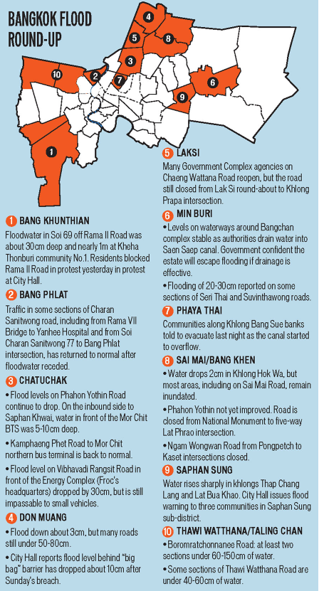
Here below there is a map of flooding situation in Bangkok as of 28 Oct 2011
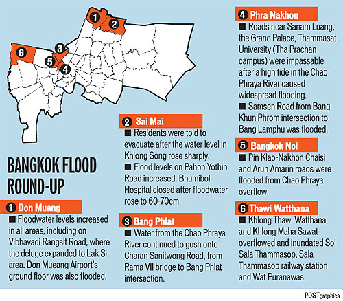
Bangkok flooding update 28 Oct 2011
It said that the highest levels of water will be reached in Chao Phraya river during this weekend and more exactly on Saturday, 29 Oct 2011, after which water is expected to decrease but again, it is not sure yet how hard Bangkok will be hit by the flooding and for how long.